
Tham Ma Slope
A picturesque landmark of Ha Giang, Tham Ma slope remains a rugged segment of Highway 4C that travelers pass through on their way from Ha Giang to Dong Van.
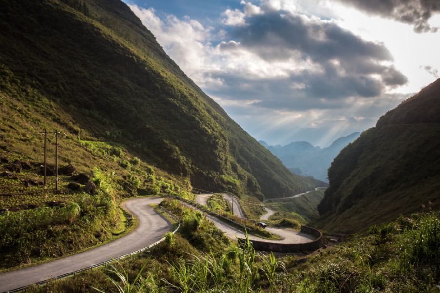 Photo by @Anh Duc
Renowned for its nine tight curves, Tham Ma slope offers more twists and turns than one might expect! It is a dream destination for riders from around the globe. The slope resembles a giant python resting under a blanket of mist. While it is generally easier to navigate on clear days, Tham Ma takes on an even more captivating and mysterious aura when enveloped in fog. Amateur scooter riders can manage the terrain as long as they ride slowly and cautiously, and having reliable front lights and horns is advisable on fog-laden days.
 Photo by @Tran Duc Hieu
Be sure to bring a drone or flycam to capture stunning aerial views of the area. Additionally, photographing local children can add unique elements of mountain life to your portfolio. Tham Ma slope continues to excite adventurous riders and charm photographers alike.
Useful Information
- Location: Tham Ma, Ha Giang
- Best for: Adventure Travelers
- Entrance: N/A
- Hours: Day time visit is recommended
- Distance to city center: 51.7km (32.1 mi)

Ha Giang Observation Deck
Unlike most people think, the northernmost point of Vietnam is not Lung Cu flag pole but a remote observation deck, which is approximately 30 minutes riding from the flagpole.

Lung Cu Peak (Ha Giang)
Lung Cu is located in Dong Van, 200km from the center of Ha Giang Borough with a natural area of 3,460 hectares.
Nam Dan Old Stone Field
The old stone field of Nam Dan was discovered in 2004 by scientists from the Institute of Archeology and the Ha Giang Museum.


